YAPP NEDİR?
Bilgisayar teknolojisindeki heyecan verici gelişmelerin mühendislik ve dizayn çalışmalarına etkileri kendisini kısa bir süre içinde gösterdi ve CAD (Bilgisayar Destekli Dizayn) olarak adlandırılan bir alanın gelişmesine sebep oldu. Bu şekilde mühendisler, daha önce sadece kalem kağıt ile gerçekleştirebildikleri, zor ve zahmetli dizayn işlerinde kullanabilecekleri çok yönlü ve esnek bir araca sahip oldular. Bu aracın başlangıçta mühendislik uygulamalarında daha çok iki ve üç boyutlu çizimlerin mekanizasyonu ve otomizasyonuna yönelik mütevazi kapsam ve boyutuna karşın, günümüzde dizayn ve mühendislik alanında bilgisayarlar sayesinde kazanılan büyük güç tartışılamaz.
Bugün, artık mühendislerin ulaşamayacağı bir şey olmaktan çıkmış bulunan bu “mikro bilgisayarlar” ile çok etkili ve çabuk bir şekilde çözülemeyecek bir dizayn problemini düşünmek gerçekten zor; yeter ki bunlar uygun yazılımlar ile donanmış olsunlar. Fakat ne yazık ki bu gerçek ile sağlanmış iyimserlik başka bir gerçeğin gölgesi altında: O da yazılım üretmenin son derece zaman alıcı ve dikkat isteyen bir işlem olması. Tuhaf görünmesine rağmen sanki bilgisayarlar inatla programlanmaya direniyorlar. Bilgisayar mimarları bu durumun farkındalar ve hızla gelişen bir teknolojinin önündeki engeli kaldırmak için daha çok yazılım odaklı bilgisayarlar dizayn etmek için mücadele etmekteler. Bu çabalar, en azından şimdilik, donanım ile yazılım arasında uzun zamandan beri kabul edilen net ayırımı bulandırdığı için, dizayn etmenin kendi başına bir yazılım sorunu olduğu gerçeği gittikçe somutlaşmakta.
Bu düşüncelerle emin olarak denilebilir ki, yazılım geliştirmek teknolojinin önemli bir alanıdır ve biz uzun yıllardan beri bu alandayız.
Karayolları Genel Müdürlüğü’ne karşı üstlenmiş olduğumuz karayolu dizayn projelerini bilgisayar ile gerçekleştirme arzumuz ile birlikte kendimizi hem korkutucu hem heyecanlandırıcı aynı zamanda da ilginç, düşünce modeli ve dizayn deneme yığınları ile savaştığımız, bir uğraşın içerisinde bulduk. Fakat bu savaşım bizim için ayni zamanda çözmeye çalıştığımız problemlerin yapısı ve tanımlanması üzerinde çok derin düşünmemiz gereken ve böylece çok deneyim kazandığımız çok değerli bir süreci oluşturdu. Bundan dolayı diyebiliyoruz ki programlama tasarım aynı şeylerdir.
Bugün kendi yarattığımız yazılımdan oluşan paketimiz sayesinde yüksek derecede otomizasyona eriştik ve “en küçük kareler” metoduyla dengeleme ve kontrol noktaları ağından başlayarak karayolu tasarımı ve tüm çizim işlerinde hemen tüm problemlerin üstesinden gelebiliyoruz.Ancak biz, bilgisayar kullanmaktaki tek amacın zaman kazanmak ve istenen sonuca çaba harcamadan ulaşmak olduğuna inanmıyoruz. Bilgisayarların efendileri için boş zaman yaratan köleler olduğuna da katılamayız. Yakın gelecekte insanların tüm fonksiyonlarının, düşünmek dahil, yaratıcılarına çok arzuladıkları boş ve geniş vakitler sağlayarak bilgisayarlar tarafından yerine getirilebileceği iddiası, en azından şimdilik, ancak bir tür spekülasyon olarak kabul edilmelidir.
Biz bilgisayarlarla sağlanabilecek esas amacın mükemmeliyete ve doğruluğa ulaşmak olması gerektiğini düşünüyoruz. Böylece yazılımımız sayesinde elde ettiğimiz, spekülasyonların ötesinde olan ve çok takdir edilen sonuçlar, onu yaratıp geliştirirken katlandığımız sıkıntıların üstesinden gelmemizi sağlayan tek motivasyon kaynağımız olmuştur.Belli tür problemlerin çözümü için yaratılmış bir yazılımın bizatihi kendisi çok zevk verici ve tatmin edici özellikte, yüksek dereceli bir tasarım olup tamamlanır tamamlanmaz da bir şekilde kendisini geçen yeni bir araştırmayı başlatır ve motive eder. Bu da, devam eden bir zincirleme reaksiyondur.
Yazılımımıza “Yol Arazi Proje Paketi”nin baş harflerini alarak YAPP adını verdik. Buradan da anlaşılacağı gibi, bu, kendi kendisini geliştiren bir düşünce ve emek sürecine verdiğimiz bir addır.Şuanki versiyonu ile 350000 civarında C++ satırından oluşan yüksek derecede nesne-esaslı bir kod durumundaki yazılımımızı ticari olarak kullanmayı asla düşünmedik ve sadece kendi iç kullanımımızda tutarak yaklaşık 10 yıldır dizayn ve çizimlerimizi neredeyse sadece bu yazılım aracılığıyla ürettik.
ÖZELLİKLER
01
Traversler ve Kontrol Ağları
Gerektiğinde tümüyle görsel ve interaktif olabilen oldukça esnek bir modüldür. Etüt ve ölçüm ekipmanlarındaki büyük ilerlemeler, günümüzde klasik ölçme kriter ve spesifikasyonlarını demode kılmaktadır. Açı ve mesafe ölçmede ulaşılan kolaylık ayıklanması gereken bir veri zenginliğini de birlikte getirmiştir. Çok iyi bilinen “dolaylı gözlemlerle en küçük kareler düzeltmeleri” na dayanan dengeleme işlemimiz, işte bu veri zenginliği ile başlamakta ve olası hataların elenerek ilerleyip bazen bir dengelemenin mümkün olmadığı veri yetersizliğini bile ortaya çıkarabilmektedir. Bu bilgi kullanıcıya olduğu gibi aktarılmakta ve dengeleme duruma göre kısmen veya tüm olarak gerçekleştirilmektedir. Aplikasyonlar için UTM projeksiyon koordinatları gerektiğinde indirgemesiz düzlemsel koordinat hesapları ile birlikte verilmektedir.
02
COGO (Koordinat Geometrisi)
Açıklanmakta olan işlerin gerçekleştirilebilmesi için yazılım, mönü zengini bir COGO ve text-sembol-nesne yönetme modülleri ve makro yaratma olanak ve motorları ile donatılmıştır. Sofistike ve güçlü olarak nitelemeye cesaret ettiğimiz COGO, geometriyi de dikkate alarak özellikle karayolu ve kavşak tasarımı için geliştirilmiş bir modüldür. Temelindeki LISP derleyicisi aracılığıyla tümüyle interaktif veya programlanabilir olup, karayolu tasarımında doğru, daire, spiral ve eğrileri kapsayan herhangi bir problem, bu güçlü araçla çok kolay bir şekilde çözülebilmektedir.
03
Haritalama ve DTM
Haritalama ve sayısallaştırılmış arazi modellemesi her altyapı tasarımı işi için hayati önemde olup YAPP’ı yaratırken bu temel görevi yapacak modülü elde edebilmek için yıllarımızı verdik. Artık iyi bilinen yerleşik “Üçgenleme Metodu”sayesinde eşdüzey eğrilerini oluşturma , detay haritalama, mevcut haritaları sayısallaştırma, kesit çıkartma ve perspektif görüntüleme artık iyi çalışır ve yıllardır hatasızlığı kanıtlanmış rutin işler durumundadır.Alışagelmiş olarak DTM diye adlandırılmasına rağmen, bu modül aynı zamanda kazılmış veya tamamlanmış yüzeylerin görüntülenmesine de fonksiyonel olarak uygun, mantıklı ve estetik olarak tatminkar çözümler elde edilmesine de yardım etmektedir.
04
Karayolu ve Kavşak Tasarımı
Hem mevcut yolların iyileştirilmesi hem de tümüyle yeni yol yapımı için geliştirilmiş olan bu modül, bu alandaki 16 yılı aşkın tecrübelerimizin sonuç ve ürünlerini içermektedir. Bir çok alt programların yanında en fazla vurgulanması gereken özellikler aşağıda verilmektedir:
- Sayısal Arazi Modeli (DTM) üzerinde Güzergah yerleştirmesi (Sayısallaştırılmış veya araziden alınmış)
- Profil, En Kesit ve Kübaj hesaplamalarıyla güzergah optimizasyonu
- İyileştirme çalışmalarında yol üstyapı ve profil optimizasyonu
- 3 Boyutlu kazı, şev teşkili , yol gövdesi arazi modellemesi
- Her çeşit görsel enkesit programlaması
- Etkileşimli veya programlanabilir kavşaklar ve kavşak tasarımları
- Tam ve otomatik taşıma optimizasyonu (Brükner)
- Son standartlar ve detay çizimler
05
LISP Derleyici
Programın yapımcısı olarak, nesne esaslı (object oriented) yapıyı sürekli geliştiriyor ve zenginleştiriyoruz. Ancak Yüksel Domaniç tarafından tasarımlanıp yazılımın hemen tümüne nüfuz eden bir özel Franz LISP editörü ve derleyicisi ayrıca zikredilmeye değer olup bununla, yaratıcı kullanıcılar için programın imkanlarını neredeyse sınırsız olarak geliştirme fırsatı sağlanmıştır.
UYGULAMALAR
3-D Perspektif Görünümler
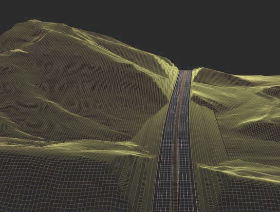
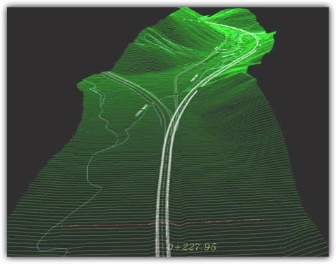
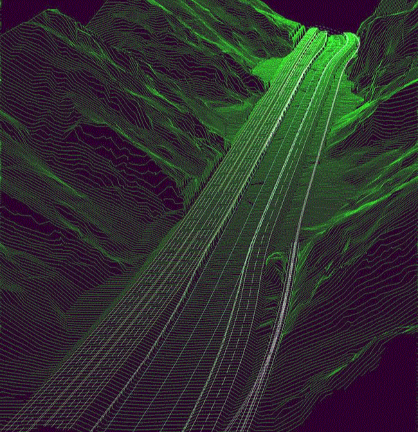
Gölcük-Pozantı Otoyolu (Km: 351+000)

Here is given a perspective view of how a motorway section would appear upon the completion of construction. It is produced by our YAPP software in PCX format and directly loaded by Word. As is seen from the picture this section of motorway (nearly 700 meters of it) is situated in a restricted river valley and just enters a tunnel of approximately 550 meters length. The river bed on the left is carefully rearranged and rip-rap protected including its’ banks. Where the river bed is immediately next to the motorway embankment, reinforced concrete cantilever retaining walls are placed for proper protection, both of which appear in the picture. Also appearing in the picture on the leftmost edge of the valley is the existing pathway serving the sparsely populated nearby rural community.
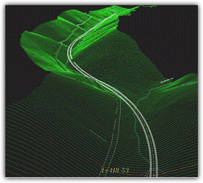
Gölcük-Pozantı Otoyolu (Km: 331+850)
This picture, also produced by our YAPP software in PCX format, shows a high cut (with a height of about 70 m.) on Golcuk-Pozanti Motorway at location Km:331+850. This high cut, upon detailed investigations and deliberations, was preferred against a tunnel with a length of over 2000 meters. The excavation, which is already completed, was in stable Cretaceous lime-stone with an RMR rating above 60. This allowed cut slopes as steep as 2 in the design. The design time previsions have proved correct and the cut was constructed without any noteworthy incident.
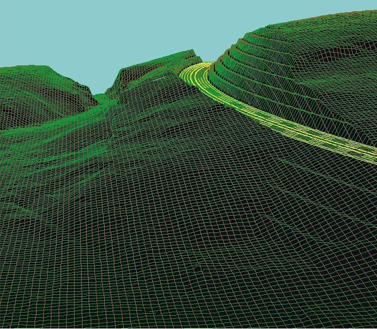
Gölcük-Pozantı Otoyolu (Km: 357+500)
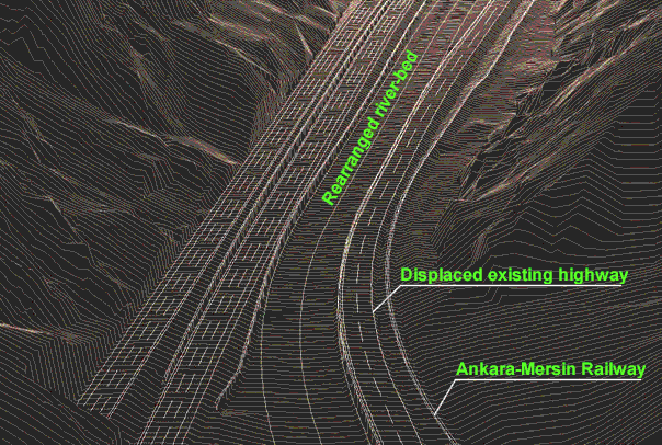

These pictures represents another striking example of alignment in restricted right-of-ways. On Golcuk-Pozanti Motorway, Cakit Valley showed such restriction in a greatest degree, in that it was necessary to accommodate the new motorway, existing Ankara-Adana-Mersin State Highway, Cakit river-bed, Ankara- Mersin Railway and a petroleum pipeline all together. The upper YAPP-perspective view shows all these elements at the location of entrance to the valley (Km:357+500) where the motorway on the left, just exits off the short Cakit Tunnel ( approx. length=250 m.). At the start, the motorway was placed on the left steep valley slopes, on client’s insistence, just not to interfere with the river-bad, railway and the existing state highway which occupied the presently right half of the motorway shown on the picture. This required long and high viaducts and retaining walls which were exceedingly difficult to construct with the heavy nearby traffic on the state highway. Besides, there was still a volume of nearly 400 000 cubic meters of excavation which couldn’t be eliminated and which was a formidable task to realize under that heavy traffic even with the use of chemicals in stead of conventional explosives. All these challenges were totally eliminated by simply adapting the solution shown on these pictures which we carefully designed through YAPP. In this solution, as is seen in the pictures, the existing highway was displaced to the right side river-bed and railway was adjusted at just a few locations. Then the new motorway was placed next to the left bank of river-bed with a precisely tuned alignment, the right half of it overlapping almost the same position of the existing highway. Finally the irregular river-bad, which already was an occasionally devastating threat to both the highway and railway, was streamlined and rearranged into a smooth alignment and heavily protected by carefully designed walls and riprap. The pipeline was also displaced to a safer position between the new highway and railway. The rather high volume of previous cuts in spite of the costly viaducts and other structures was now reduced to under 25 000 cu.m. and thus virtually eliminated, providing uncomparable ease in construction. The result was a composition of manifold gains over the former decision in that now all the transportation infrastructure was much more better protected against the always challenging Cakit River, the railway was realigned with higher geometric standards and all these with over 40 million $ reduction in the cost of construction for a section of motorway with a length of about 6 km. The above pictures, where the second continues the first, shows part of this motorway section in Cakit Valley which is not wider then 100 meters in long spans.
Büyük Bir Dolgu veya Masraflı Bir Köprü...
In the design of motorways where highest standards are aimed by the very nature of the infrastructure in question, even in moderate topography high cuts and fills are inevitable. At such locations it is a well known dilemma, or quiz if you like it, whether it is preferable to achieve the passage by a tunnel or viaduct instead of a high cut or fill respectively. The Gedelozu Valley passage at location Km:335+000 on Golcuk-Pozanti Motorway supplied a typical example of such deliberation. To give way to the small stream in the deep and wide valley through a moderate culvert was easy and hydrologically not threatening. The rock-bed of the valley lied not very deep and the bearing capacity was quite suitable to carry a high fill for which qualified material was also readily available from the nearby rock excavations. Yet the valley was relatively reach with verdure and vegetation as well as trees and consequentially negative impact of such a huge fill as represented in the above YAPP-perspective view was of great environmental concern. After careful studies and long deliberations a high viaduct with a length of over 500 meters was decided as the better solution in spite of its high cost which was more than two times that of the fill.
Kazıdan sonra ortaya çıkan çıkıntılar neden kaldırılmıyor?
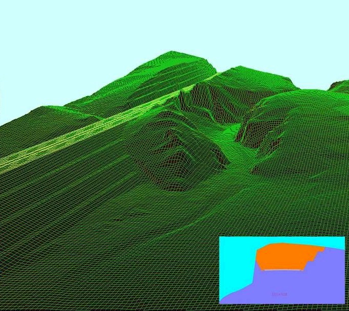
This picture also shows a perspective visualization, by our YAPP software, of the topography with the motorway body dug into it, filled and finished around the location Km:333+500, again on Golcuk-Pozanti Motorway. Carefully constructed alignment just prevented interference with the side valley. But known serious winter conditions suggest that the high cut appearing in the picture must be made clear to the valley removing the thin ridge between it and highway body. The cross-section taken at a position where this ridge is slimmest clearly justifies the asserted optimization and the manifest design advantage provided by the software.
Yarma ve Dolgular... (Km:338+750)
This picture, also produced by our YAPP software in PCX format, shows four high cuts and one interlaying voluminous fill in a series at location Km:338+750 ,as is the usual configuration for motorways, placed in rough or even moderate topagraphy. As already explained in the description of a huge fill in a previous page, decision betwwen such kind of high-volume but cheaper earthwork and much more costly bridge and tunnel structures is usually based on the severity of negative environmental impact and adverse geotechnical conditions.In the example represented by the above view these were rather favorable as the Kirkgecit Valey where this section was sitiuated was in an unpopulated vicinity with sparse vegetation and a geology dominated by stable and solid spilitic basalts.
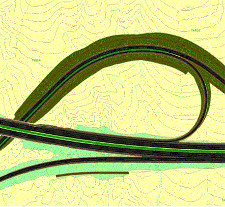
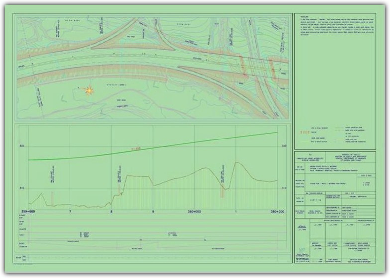
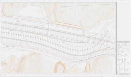
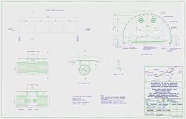
Kavşak Tasarımı
Gölcük Pozantı Otoyolu Üzerindeki Eminlik Kavşağının Tasarımı (Km: 328+000)
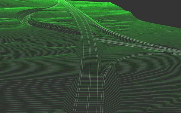
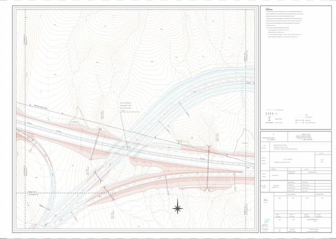
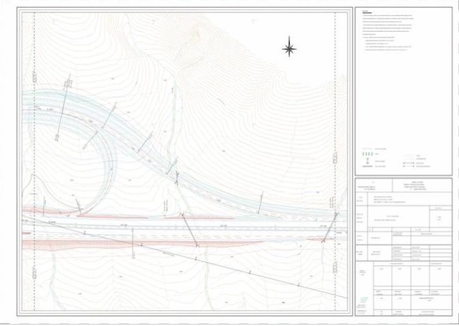
The perspective view in the top picture aims to create an idea of how it would appear when the Eminlik Interchange, presently under construction, is completed. This important Interchange on Golcuk-Pozanti Motorway at location Km:328+000 diverts more than 40% of the Ankara-Adana traffic to western part of the country. The drawings following it shows a detailed layout of this interchange where cuts, fills, drainage ditches as well as pavement surface with many other details are given. With YAPP one can create such layouts, drainage plans, coordinate and elevation annotated earthwork and pavement plans etc. to any degree of detail and precision for which many more examples are provided in our other web pages.
YAPP Yüzey Tanımlamanıza Yardımcı Olur...
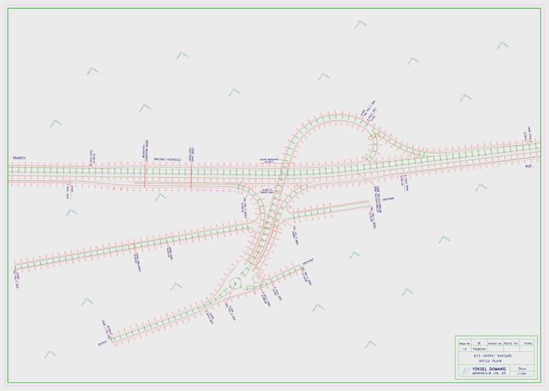
Besides creating perspective views and detailed interchange layout design as shown in the precious examples YAPP offers many more means and possibilities in defining and creating your surfaces. You can define layers of surfaces and assign elevations (profiles) to any curve on them by means of layer and multi-route capabilities built into YAPP. You can also make use of super elevation curves or any other carrying method of your own definition to create these profiles. Then you can smooth them properly, instantly redefining your surface in this way. This is much more than the classical route-interchange design by the well known plan-profile method. By this way, you can create very detailed elevation plans of surfaces such as sub-base, base and/or pavements as well as earthworks ready to be fed to construction. Following drawing shows such an interchange pavement plan on the Northern Costal Highway which is presently under construction.
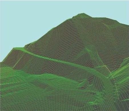
Koridor Keşifi ve Güzergah Seçimi
Detaylar
Route selection is a complex and often a formidable task depending upon very many and diverse factors. As such it is certainly impossible to automatize this vital process however sophisticated the software system and powerful the computer on which it runs might be. The human brain and experience is still the irreplaceable master in this field against all the self exceeding claims of Artificial Intelligence proponents and enthusiasts.
Yet that the computers are great aids to human intelligence in this tough enterprise is beyond any doubt. YAPP has been designed always keeping this potential in mind. It has many capabilities such as quickly and automatically viewing the cross-sections of a trial route, earth-work volumes, operation, slope and altitude statistics and other characteristics of horizontal and vertical alignment.
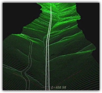
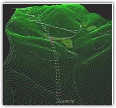
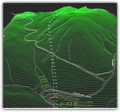
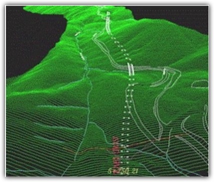
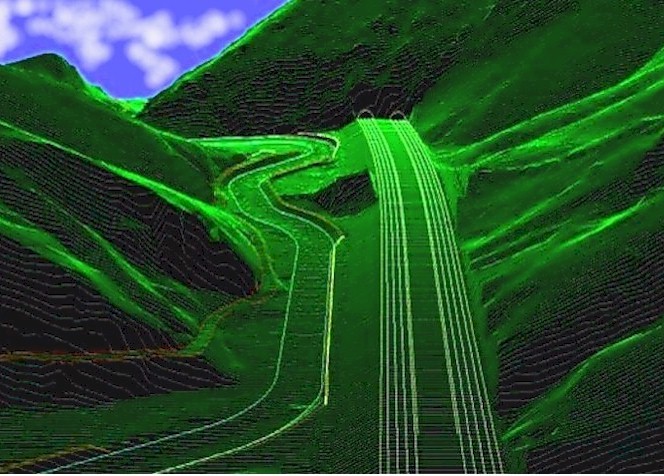
Another ambitious attempt of YAPP is to simulate a flight in the route corridor continuously following it. This is easy to prepare as a reconnaissance trip along the corridor in that it requires only a sufficiently detailed terrain model and trial routes under inspection.
The pictures in this page gives instances of such a trip over Camlibel corridor in rough terrain which is carefully mapped by our survey team with an approximate length of 9 km. They show views at 7 successive stations. The trial route enters a tunnel at about km:4+250 and leaves it off at Km:5+250. You can freely move in the land as well as follow the trial route and can at times get the feeling of flying depending on the speed and power of your computer.
Standart Karayolu Tasarım Paftaları
Detaylar
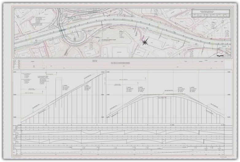
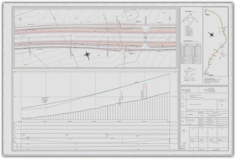
Frequently encountered prophesies that paper, as an information holding and conveying medium is on the way of soon becoming obsolete, have not proved correct. Books continue to abound and you would hardly dispense with the enjoyment of reading your thriller while lying back in your bed.
The design sheets, for that matter, are liable to much more theoretizing about whether they are really best means to present the contents of a design. That this is not so, seems to be pretty firmly established even today. Yet they are persistingly on the tables of engineers of nearly any tradition and upbringing. They surely have many attributes indispensable in someway or other.
To convey highway design content to the executors and others concerned is a tough task. Clients widely differ as to the format and the intensity of information put in a sheet. In an age where automatization is at a ran, this is a serious and difficult problem to tackle with. The solution seems to be in the built-in flexibility and programmability of the software system used, which in turn is in conflict with the ease of use. With YAPP, experience induced us to put the preference on the first, resulting in a rather sophisticated and flexible software.
The design sheets given in this page exemplify different requirements by two departments in the same General Directorate. With YAPP they could be easily solved by menu selections only. But in case of more singular and specific requirements and further customization, the solution is in built-in LISP programmability which puts considerable demand on user ability.
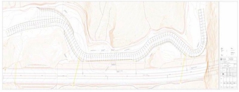
Banket Koruması ve Nehir Mühendisliği
Gölcük-Pozantı Otoyolu Üzerindeki Kırkgeçit Vadisinin Dere Yatağı Düzeltmesi ve Banket Koruması (Km: 358+000)
The perspective view in the top picture showing a carefully aligned section of Golcuk-Pozanti Motorway is already explained in sufficient detail in another page. We repeat it here to introduce a river engineering design example within this project. The Cakit River has always been a threat to the Ankara-Adana State Highway, and Ankara-Mersin Railway on its left and right banks respectively. In the new arrangement shown in this view, another major transportation structure, namely Golcuk-Pozanti Motorway, has also been placed in the same narrow valley. This could be achieved by displacing the state highway on the left to the opposite bank, between the river and railway. The river bad has been carefully realigned and streamlined as is shown on the above design sheet. The new banks almost entirely formed by reinforced concrete cantilever walls with rip-rap protection in front of them. The design is based on the US, Corps of Engineers practice with a river runoff flow rate of 1000 cubic meters/second for walls and 600 cubic meters/second for the rip-rap.
Gölcük-Pozantı Otoyolu Üzerindeki Kırkgeçit Vadisinin Dere Yatağı Düzeltmesi ve Banket Koruması (Km: 351+000)
The top picture, already appeared in another context in these pages, shows an example of bank protection both by rip-rap and reinforced concrete cantilever walls. The stream in Kirkgecit Valley has a calculated runoff flow rate of 300 cubic meters/second and as is clear from view and drawing above, would create a serious threat for the motorway embankment if left unprotected. The cantilever walls appearing at two sections, have the double duty of both confining the motorway embankment from intruding into river bed and protecting it against the flow. The other bank sections where the river main flow line is more away are protected only by rip-rap. The same type of protection applied also to river bed all along the section length. In this case also, the design was based on US, Corps of Engineers practice and the sharply curved section at about the tunnel entrance portals required use of stones heavier than 1 ton.
Bazı Tasarım Örnekleri
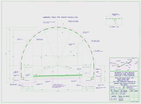
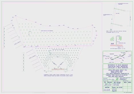
Tünel Tasarım Örneği: Kuzey Karadeniz Sahil Yolu Üzerindeki Çamburnu Tüneli
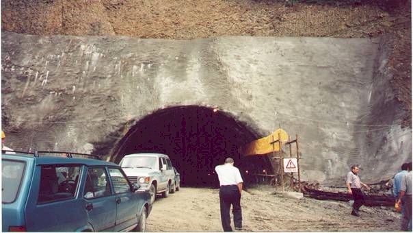
Camburnu was a wonderful location by the seaside with a spectacular landscape on the Northern Costal Highway. Thus when the existing two lane highway was decided to be rehabilitated and widened against the always challenging traffical demand, it deserved just every care to be kept intact. Our solution was to utilize the existing two lanes for one direction of the planned new four lanes divided highway. The additional two lanes for the other direction was decided to be provided by a tunnel, entrance location of which is marked on the side view.
The design was based on the NATM, supplemented with all the modern techniques such as 2-D and 3-D Finite Element Analysis through LUSAS and Rockscience Software.
The photograph below shows nearly completed portal excavation with the support described in the drawing just under it. The other two drawings show the two- lane tunnel cross-section and the ventilation equipment. YAPP has been intensely utilized in the design to create, model and process the basic data as well as produce the drawings.
Köprü Tasarım Örneği: Gölcük-Pozantı Otoyolu Üzerindeki Çakıt-8 Köprüsü
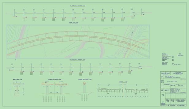
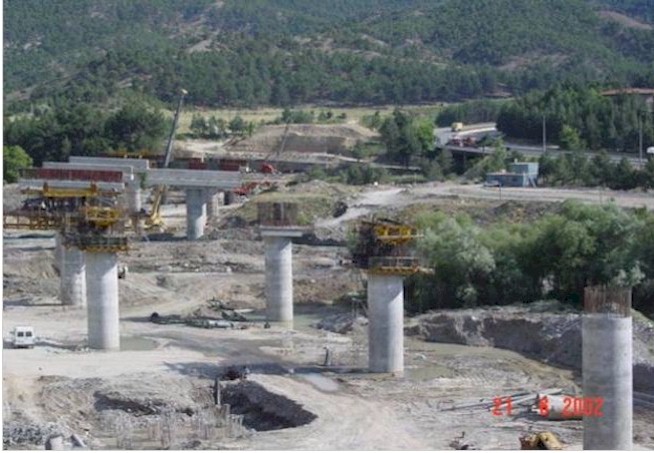
Cakit-8 was the last bridge spanning over the Pozanti-Cakit river with a length of more than 400 meters on Golcuk-Pozanti Motorway. It merged the designed motorway into the existing one in the Adana direction. Following drawing which is processed and produced by YAPP shows the layout of this long bridge which presently is under construction. YAPP can ,for certain, be qualified as versatile tool in creating such layouts thanks to its powerful COGO, many sectioning and multi-route viewing abilities as well as 3-D processing and visualization capabilities.
Karayolu Planlama Ve Tasarım Prosedürü
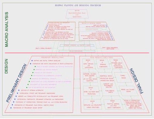
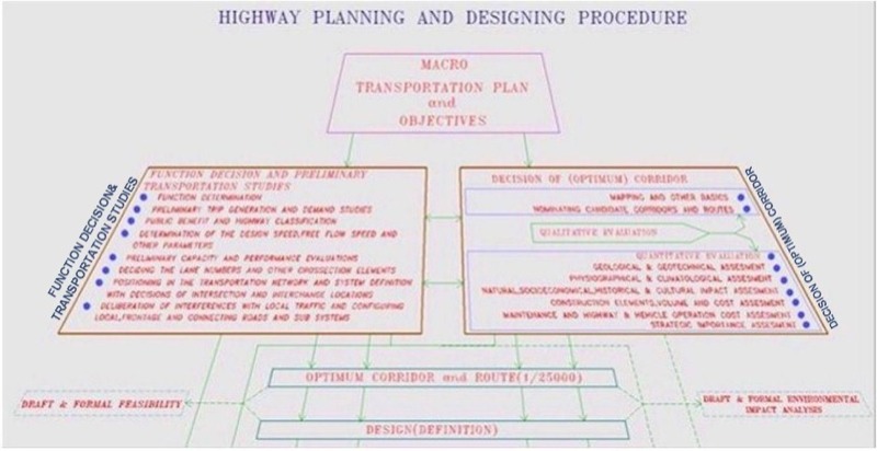
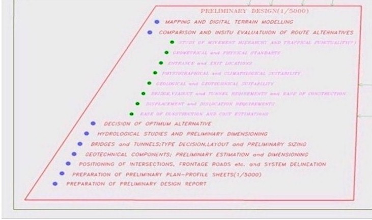
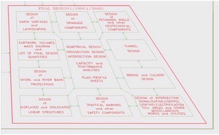
Highway planning and designing is an extremely interconnected “system procedure” where one starts from “Macro Analysis” at an all encompassing and far reaching “perspective point”. Only then can one meaningfully zoom and zero in on the design stages. This system approach and flow-charting appearing in the following schema, which is a construct of ours, has been adopted to be among the official documentation by the State Department of Highways. Other pictures zooms on the components i.e. boxes of this schema in correspondence with the actual proceeding of the procedure.